Learning About Indiana History

|


|
|


|
|
|
Unit 1: Indiana's Land and People ~ Summary
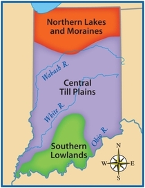
Many of Indiana's landforms are the result of glaciers that moved across the region during the last Ice Age. The state's landscape can be divided into three regions: the Northern Lakes and Moraines, the Central Till Plains, and the Southern Lowlands. Hoosiers enjoy all four seasons. In northern Indiana, the lake effect from Lake Michigan produces heavy snowfall in the winter and cool temperatures in the summer.
Indiana is rich in natural resources. Coal, natural gas, petroleum, oil, and limestone support our state's economy. The Central Till Plains provides Indiana farmers with fertile soil to grow corn and other products. Agriculture, along with manufacturing and mining, are important to our state's economy.
More than 6 million people live in Indiana. Many Hoosiers can trace their roots to Europe, Africa, Asia, or Latin America. These various cultural groups make Indiana a diverse state. As citizens of Indiana, Hoosiers also share a common heritage through celebrations and sporting events.


Standard 3 ~ Geography: Students explain how the Earth/sun relationship influences the climate of Indiana; identify the components of Earth's physical systems; describe the major physical and cultural characteristics of Indiana; give examples of how people have adapted to and modified their environment, past and present; identify regions of Indiana, and compare the geographic characteristics of Indiana with states and regions in other parts of the word.
4.3.1 Use latitude and longitude to identify physical and human features of Indiana. Ex. transportation and bodies of water (lakes and rivers)
4.3.2 Estimate distances between two places on a map when referring to relative locations.
4.3.3 Locate Indiana on a map as one of the 50 Unites States. Identify and describe the location of the state capital, major cities and rivers in Indiana.
4.3.4 Map and describe the physical regions of Indiana and identify major natural resources and crop regions.
Example: Northern Lakes and Moraines, Central Till Plain and Southern Lowlands
4.3.5 Explain how glaciers shapes Indiana's landscape and environment.
4.3.6 Describe Indiana's landforms (lithosphere*), water features (hydrosphere*), and plants and animals (biosphere)
*lithosphere: the soil and rock that form Earth's surface
*hydrosphere: all the water on Earth's surface, including the hydrologic cycle (precipitation, evaporation, and condensation)
*biosphere: all plants and animals
4.3.7 Explain the effect of the Earth/sun relationship on the climate of Indiana
Example: Describe seasonal changes and use USDA hardiness zone maps to select plants and tress for a community park.
4.3.8 Identify the challenges in the physical landscape of Indiana to early settlers and modern day economic development.
Example: Forest growth and transportation routes
Click on textbook link above.
|

|

Click on link above.
Click on link above for FT Blendspace Resources.